Nuuk Marluk
  • Home
  • Blog

Inuit Cartography

7/19/2011

8 Comments

 
As a cartographer looking for work in Nuuk, I've become pretty interested in what sort of historical mapping and base data (potentially useful to yours truly) are available for Greenland. In my research I've learned about some interesting cartographic specimens that use wood as their medium. Unfortunately these won't be too immediately useful to me as they're not exactly geodatabase-ready... but interesting subject matter nonetheless.
Picture
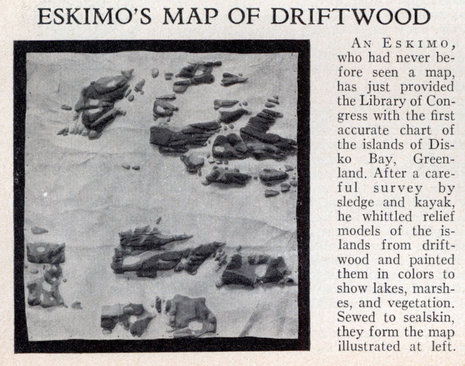
Excerpt from the September 1933 issue of "Popular Science".

I pulled the article clip at left from the blog Modern Mechanix, which reprints items from old Popular Science magazines. Pretty cool, if a bit lacking in political correctness. 

I wonder about the claim that the "eskimo" had "never before seen a map." Perhaps not a paper map-- but as you'll see below, there are other options.


Picture
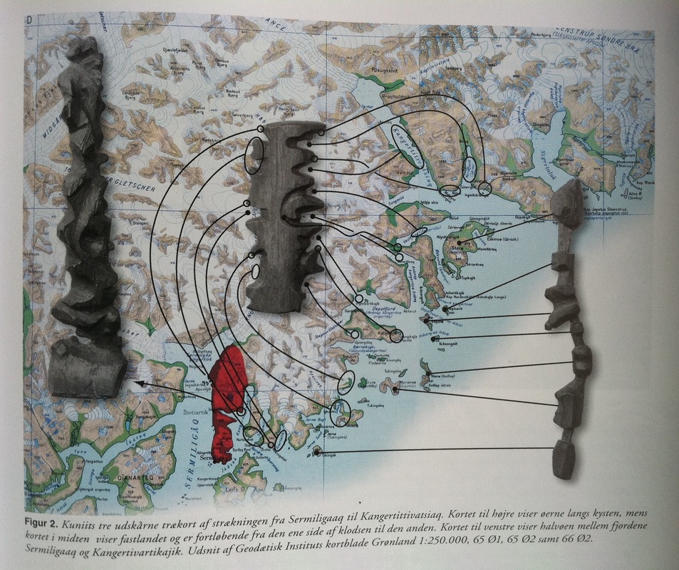
In English, the caption reads: "Kuniit's three wooden (tree) maps show the journey from Sermiligaaq to Kangertittivatsiaq. Map to the right shows the islands along the coast, while the map in the middle shows the mainland and is read from one side of the block around to the other. Map to the left shows the peninsula between the fjords Sermiligaaq and Kangertivartikajik." From "Topografisk Atlas Grønland", published by Det Kongeglige Danske Geografiske Selskab, 2000 (pg 171).


Picture

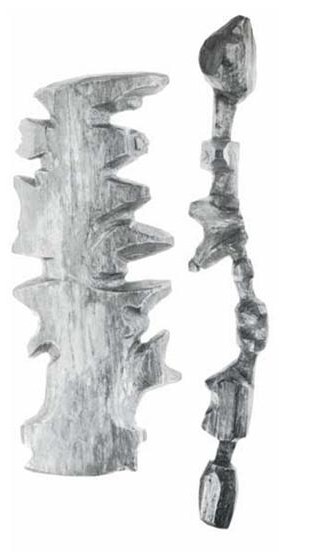
At left, a closer look at the maps. Apparently they were "discovered" in 1880 by a Danish explorer named Gustav Holm, who was leading an expedition to the Ammassalik coast of eastern Greenland. I'm not sure if similar maps exist for the west coast (although the carved map featured in the Popular Science article above is from the west coast.)  

I'm especially enamored with the fact that the maps are meant to be read up one side and down the other. Who needs a north arrow?? Not these guys. Very efficient use of space that I may employ in the near future.

From some accounts I've read (source: general googling), it also seems these maps were carved more to be felt than actually read-- which does seem quite practical for kayak or boat travel in potential darkness. 

If you'd like to find out more, I believe all of this is properly and academically chronicled in The History of Cartography, Volume 2, Book 3: Cartography in the Traditional African, American, Arctic, Australian, and Pacific Societies. A nice beach read for a lazy summer afternoon.

8 Comments
Ryan O'Donnell link
7/20/2011 03:08:43 am

Cool! The island map seems like a bit of a stretch - the relative sizes of islands don't seem to match up very well, and several of the larger islands are completely missing. I wonder if the scientists misinterpreted its location and/or scale? The central, wrap-around map seems right on and is very convincing. I also wonder if the wrap-around point on the central map might indicate home for the carver?

Reply
Yugan link
9/4/2016 06:16:13 am

Maybe the maps are scaled to a man rowing a kayak. A stretch across the ocean may not be far in a straight line, but there may be currents that make it "further away" than another place.

Reply
jerry
7/25/2011 03:19:44 am

I like this kind of stuff. Seems many primitives had such method of getting around. I think, though, that I would rather be kayaking/canoeing around in the south pacific rather than the far north. http://thenonist.com/index.php/thenonist/permalink/stick_charts/

Reply
Barbara Liles
10/13/2011 07:52:26 am

Anna, I am thrilled to see the wooden maps and to find your blog. I am a writer/ex-teacher/children's librarian and am writing a historical fiction about the demise of the Norse settlements in Greenland. I found the maps in my research and they are worked into my story. I'm realizing that I may need to actually go to Greenland, but until then I'm trying to find English speaking folks in the area who might be willing to answer questions for me. Please let me know if you are interested!
Thanks, Barbara
www.quirkytales-oldandnew.blogspot.com/
http://bel-biblio.blogspot.com/


Reply
Justin Kolbek
9/13/2016 02:22:59 pm

This article is very interesting. What interests me a lot is how the people who found these maps determined that they were maps and not just simply objects. It was a great idea to intend for the maps to be felt, as well as observed. To me, looking at the map would give a good picture of what the area looked like, whereas feeling it could give a different picture of the type of terrain, altitude, and so forth.

Reply
Carol Chacon
9/14/2016 08:39:00 am

What I find interesting about this article is the idea of the many different types of maps that exist in the world. Today, we are used to the traditional map but little did I know that there were other forms of mapping a long time ago. The map used by an eskimo was a carving of a route and read from up to down on one side and down-up on the other. This proves that there is no exact way to really create a map, as long as it gets you from point a to b.

Reply
Mabande
7/1/2017 09:04:37 am

These are really interesting!

A thought struck me when shown the facsimilie from Topologisk Atlas on Twitter today (six years after your post): I think the authors positioned the peninsula carving in the opposite North/South direction, cause if you follow the coast line on the tactile map it makes more sense to flip it due to the recession on the lower left side of it matches the large bay on the northeast side of the peninsula in the paper map (and following the topology of the wooden map it's pretty much a replica of the peninsula) :)

Reply
English To Telugu Translation link
5/20/2022 05:21:31 am

These are really interesting!

Reply


Leave a Reply.

    Author

    Anna is a self-employed GIS specialist/cartographer. Ken
    is a hydrologist working for    
     ASIAQ Greenland. 
    They like the mountains.

    Picture

    Archives

    March 2012
    February 2012
    January 2012
    November 2011
    October 2011
    August 2011
    July 2011
    June 2011
    May 2011

    Categories

    All
    Aapakaaq
    Afghanistan
    Alcohol
    American Experience
    Architecture
    Art And Culture
    Babies
    Backcountry Skiing
    Barnevogns
    Boats
    Bouldering
    Bus
    Cafes
    Camping
    Climate Change
    Climbing
    Cost Of Living
    Danish
    Fishing
    Fog
    Greenland Institute Of Natural Resources
    Guide Books
    Hiking
    Housing
    Ice
    Icebergs
    Katuaq Cultural Center
    Kayaking
    Kobbefjord
    Local Food
    Maps
    Mold
    Mountains
    Muktuk
    Muskox
    Nuuk
    Photography
    Qinngorput
    Qoornoq
    Science
    Store Malene
    Transportation
    University Of Greenland
    Walking Culture
    Weather

    RSS Feed


Proudly powered by Weebly